Sales & land value at a glance
The official record, not an estimate.
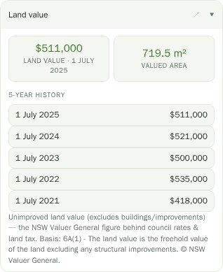
Automated valuation estimates are everywhere and they are all modelling something. The Sales & market and Land value sections do not model anything: they show the sales the NSW Valuer General has recorded around the site, and the land value the Valuer General has determined for that parcel.
That distinction matters for development work. A land value is the unimproved value of the land as assessed for rating and land tax — it is not what the property would sell for with the house on it, and it is not a valuation of your proposal. But it is a consistent, official, per-parcel number, which is more than most inputs to a feasibility can claim.
Sales in context, on the map.
Because sales sit on the map next to the cadastre, the zoning and the constraints, you can see the thing a table of comparables hides — whether the sale two doors up was a similar lot or half the size, whether it was in the flood planning area, whether it had the same frontage.
Select several lots with multi-property compare and their values line up side by side, which is the quickest way to sanity-check a site’s asking price against its neighbours.
Questions
Is the land value what the property is worth?
No. It is the Valuer General’s assessment of the unimproved land at a base date, used for rating and land tax. A property with a house on it is generally worth considerably more than its land value, and a site with development approval may be worth more again.
How current are the sales?
They are as current as the Valuer General’s published release, which lags actual settlement. Expect recent sales to be missing rather than wrong.
Do you show sales for the selected lot itself?
Where the Valuer General has recorded one, yes — and the sales around it, which is usually the more useful part for pricing a development site.
Can I get sales into a report?
Yes. Sales are one of the optional sections in the branded PDF site report, alongside the cover, maps, development potential, standards, hazards and demographics.
Why not use a commercial property data provider?
Because the official record is free, properly licensed for us to redistribute, and covers every parcel in the state. Commercial datasets add agent listings and estimates on top; they also add a per-seat cost that would end up in your subscription.