Reports & exports at a glance
One report, only the parts you need.
The full site report is the deliverable most people generate: a branded PDF built from the same analysis on screen. Rather than a fixed template, the sections are toggles — cover, maps, development potential, development standards, hazards, sales and demographics — so a quick constraints check for an internal file and a full pack for a client come out of the same button.
The survey sketch is the short one: a clean plan of the parcel with boundary bearings and dimensions, with neighbouring lots, contours and survey marks each switchable on or off depending on what the page is for.
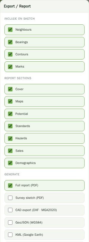
And out into the tools you actually work in.
DXF writes on MGA2020, so the file lands on an existing survey or civil job without reprojection. LandXML covers the survey and civil packages that prefer it. GeoJSON in WGS84 goes into QGIS or ArcGIS, KML into Google Earth for the walkthrough, and the boundaries CSV into a spreadsheet when someone wants the numbers rather than the geometry.
For 3D work there is a glTF massing export of the modelled envelope, and if none of that is what you needed, a plain print of the map view is one click away.
Which output for which job
| Format | Use it for | Notes |
|---|---|---|
| Full report (PDF) | Sending a client or a lender a site analysis | Branded; cover, maps, potential, standards, hazards, sales and demographics are individually switchable |
| Survey sketch (PDF) | A one-page plan for the file | Bearings and dimensions; neighbours, contours and marks optional |
| CAD export (DXF) | Starting a drawing in AutoCAD or Civil 3D | MGA2020 — no reprojection needed |
| LandXML | Survey and civil packages | Boundary and, optionally, contours |
| GeoJSON (WGS84) | QGIS, ArcGIS, web mapping | WGS84 as the format requires |
| KML | Google Earth walkthroughs and client presentations | Opens on anything |
| 3D massing (glTF) | Bringing the modelled envelope into a 3D tool | Indicative massing, not a design model |
| Boundaries CSV | Spreadsheets and take-offs | Dimensions as numbers |
| Print map view | When you just need the screen on paper | Straight through the browser |
Questions
Is the PDF report branded?
Yes — it generates as a branded document you can send on. The section list is yours to choose, so it can be a two-page constraints check or a full pack.
What projection is the DXF?
MGA2020, in the correct zone for the site. That is what NSW survey and civil files use, so it drops straight onto an existing job.
Can I export more than one property at a time?
Yes. Multi-property selection has its own export — save all the selected lots, or take them out as CSV or GeoJSON together.
Do exports need Pro?
Yes. Generating reports and CAD/GIS exports is a Pro feature. Searching, cadastre, zoning, hazards and the on-screen site report are free.
Can I put a site report in front of a client as advice?
Not as advice, no. It is an indicative research summary built from public datasets and it says so on every page. Use it to inform advice that a suitably qualified person gives.