Multi-property compare at a glance
Amalgamation, without the arithmetic.
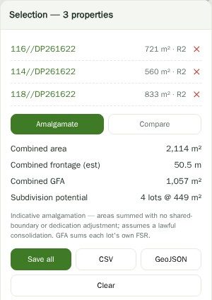
The site that works is very often two lots, or three. But every control that decides whether it works — minimum lot size, floor space ratio, the dwelling yield, whether it clears the threshold for a different development type entirely — applies to the amalgamated parcel, not to the pieces.
Select the adjoining lots and the panel treats them as one site: combined area, the resulting frontage, and the development potential that the combination unlocks. That is frequently the difference between a site that supports a duplex and one that supports something considerably more interesting.
Or compare, when they’re not neighbours.
The other half of the tool is comparison. Select several unrelated sites — three listings you are weighing up, or every lot you have shortlisted out of a site finder scan — and the panel lays their attributes out side by side: zone, area, frontage, minimum lot size, floor space ratio, height, and the constraints attached to each.
Reading four site reports in sequence and trying to hold them in your head is how the wrong one gets bought. A table is better.
Then take the selection with you.
A selection is not just a view. Save every selected site at once, export the whole set as CSV for a spreadsheet, or as GeoJSON to take the geometry into QGIS or hand to someone else.
It pairs naturally with the site finder: scan a suburb, shortlist the matches, multi-select the ones worth a closer look, compare them properly, and export what survives.
Questions
How do I select more than one lot?
Turn on the multi-select tool in the toolbar and click each lot you want, or shift-click lots on the map. Click a selected lot again to drop it.
Does amalgamating lots on screen change anything legally?
No. It is a calculation over the combined geometry. Consolidating titles is a separate legal process, and whether it can be done at all depends on ownership, the title, and council policy.
Can I compare lots that aren’t next to each other?
Yes — that is the compare half of the tool. They do not need to adjoin. Amalgamation figures only make sense for parcels that actually touch.
What comes out in the export?
CSV for the attributes in a spreadsheet, or GeoJSON when you want the geometry as well. You can also save every selected site at once.
Does this work with the site finder?
Yes, and it is the natural pairing: scan a suburb, then multi-select the shortlist from the results and compare them properly.