Housing reform layers at a glance
Whether the reforms reach your site is a map question.
The Low and Mid-Rise Housing reforms and the transport-oriented development precincts changed what is permissible on a large number of NSW lots — dual occupancies and terraces in places that previously allowed neither, mid-rise near stations and centres. But none of it applies everywhere. It applies inside mapped areas, with mapped exclusions carved back out of them, and the boundary is often a street.
Switch on the reform overlays and the answer is visual: the site is inside the area, or it is not, or it is inside the area but also inside an exclusion — which is the case people miss, because the two layers have to be read together to be read correctly.
And it is checked on the lot, automatically.
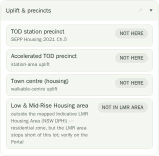
You do not have to remember to look. The Uplift & precincts section of the site report tests the selected parcel against the Housing SEPP precinct layers as part of the normal analysis and reports what it finds — LMR area, TOD site, Accelerated TOD precinct, town centre, greenfield housing code, urban release area, and any exclusion that applies.
It shows up in the site finder too. An R2 lot that would only support multi-dwelling development if it sits inside a mapped LMR area is tagged as a question rather than claimed as a match, because in R2 the zone alone does not settle it.
Drawn from our own cached vectors.
The government publishes these layers as map services that are slow, occasionally down, and rendered as fuzzy raster tiles. We cache them as vectors on our own infrastructure and draw them natively, which is why they appear instantly, stay crisp at any zoom, and can be clicked for the underlying attributes rather than just looked at.
One layer — the DPIE LMR service — cannot be queried for its geometry, so it is proxied through our server rather than vectorised. It is the one that will be a little slower than the rest.
Questions
What is an LMR exclusion area?
A mapped area carved out of the Low and Mid-Rise Housing reforms, where the uplift does not apply despite the surrounding area being within scope. Because it overrides the LMR layer, the two must be read together — which is exactly why both are shown.
Does being in a TOD precinct mean I can build an apartment building?
No. It means the transport-oriented development provisions are potentially in play for that site, with their own standards and criteria. Permissibility still depends on the instrument, the zone, the site’s constraints and the specific proposal.
Why does the site finder say "Multi · LMR?" instead of just matching?
Because for an R2 lot, multi-dwelling potential turns on whether the site is inside a mapped LMR area rather than on the zone alone. Rather than claim it either way, the finder flags it as a question and the site report runs the actual precinct check when you open the lot.
How current are these layers?
They are rebuilt from the published NSW source on a periodic basis. For anything time-critical, confirm against the NSW Planning Portal, which is the live authority.
Do reform layers cost extra?
No. They are part of the map overlays and the site report’s uplift section, which are not Pro-gated.